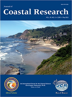
Otter Rock, Central Oregon Coast, USA. The small community of Otter Rock along the central Oregon coast shows convincing evidence of the tectonic activity found in this area. Being located within the Cascadia Margin where the Juan de Fuca ocean plate is subducted beneath the continental North American plate, this geologic anomaly is the location of various major subduction earthquakes during the past several thousand years, with the most recent having been a magnitude 9 event on 26 January 1700 (this event was accompanied by a tsunami that inundated the entire coast). During that earthquake and others in the past, the coast abruptly subsided on the order of 1 to 2 meters, but in the centuries between earthquakes when the subduction zone is "locked" and storing energy, the coast experiences slow tectonic uplift. The present-day rates of uplift, which vary along this coast, are demonstrated in tide-gauge records of trends in relative sea levels. While some stretches of this coast are tectonically rising faster than the global-average rate of sea-level rise, this photo represents an area of increasing relative sea levels and therefore experiences higher rates of erosion and property damage.
The prominent wave-cut terrace (Otter Crest), as seen in the photo, is the youngest in a series of tectonically uplifted terraces and ancient beach deposits found along the Oregon coast. The Otter Crest terrace is composed of a moderately resistant Tertiary marine siltstone, overlain by a Pleistocene beach deposit. This exposure of an ancient sand beach reveals closely similar sedimentary structures, patterns of sand grain sorting, and even the presence of drift logs that are also found on the adjacent modern-day beach; a prime example that "the present is the key to the past." The modern-day pocket beach is extremely rich in heavy minerals, which had been mined for gold during the late-19th century. With the sand composed of a variety of minerals (magnetite, garnet, augite, etc.) and having a range of densities and grain sizes, this beach serves as the basis for research into the processes of mineral sorting by waves and currents, which leads to the formation of black-sand beach placers. Cape Foulweather in the background, having a volcanic origin, was named by Captain Cook in March 1778, presumably during weather and storm-wave conditions that are more typical of this Oregon coast. A spectacular view is also offered from atop the Cape looking down onto the Otter Crest terrace, including a volcanic ring dike seen within the intertidal zone. (Photograph taken by Paul D. Komar, College of Earth, Ocean, and Atmospheric Sciences, Oregon State University, Corvallis, Oregon, USA.)

©Coastal Education and Research Foundation, Inc. 2023


